


Quay County Precinct 1, Quay County, New Mexico
About
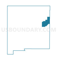
Outline

Summary
| Unique Area Identifier | 623817 |
| Name | Quay County Precinct 1 |
| County | Quay County |
| State | New Mexico |
| Area (square miles) | 396.20 |
| Land Area (square miles) | 396.19 |
| Water Area (square miles) | 0.01 |
| % of Land Area | 100.00 |
| % of Water Area | 0.00 |
| Latitude of the Internal Point | 34.73413850 |
| Longtitude of the Internal Point | -103.94404890 |
Maps


Graphs
Select a template below for downloading or customizing gragh for Quay County Precinct 1, Quay County, New Mexico


Neighbors
Neighoring Voting District (by Name) Neighboring Voting District on the Map
- Curry County Precinct 4, Curry County, NM
- De Baca County Precinct 3, De Baca County, NM
- Guadalupe County Precinct 1, Guadalupe County, NM
- Guadalupe County Precinct 3, Guadalupe County, NM
- Quay County Precinct 11, Quay County, NM
- Quay County Precinct 2, Quay County, NM
- Quay County Precinct 6, Quay County, NM
- Roosevelt County Precinct 6, Roosevelt County, NM
Top 10 Neighboring County Subdivision (by Population) Neighboring County Subdivision on the Map
- Tucumcari CCD, Quay County, NM (7,014)
- Santa Rosa CCD, Guadalupe County, NM (3,519)
- East De Baca CCD, De Baca County, NM (1,759)
- Elida CCD, Roosevelt County, NM (1,166)
- Melrose CCD, Curry County, NM (1,118)
- House-Forrest CCD, Quay County, NM (298)
Top 10 Neighboring Place (by Population) Neighboring Place on the Map
Top 10 Neighboring Unified School District (by Population) Neighboring Unified School District on the Map
- Tucumcari Public Schools, NM (6,943)
- Santa Rosa Consolidated Schools, NM (4,455)
- Fort Sumner Municipal Schools, NM (2,022)
- Melrose Public Schools, NM (1,156)
- House Municipal Schools, NM (258)
Top 10 Neighboring State Legislative District Lower Chamber (by Population) Neighboring State Legislative District Lower Chamber on the Map
- State House District 67, NM (25,041)
- State House District 63, NM (24,938)
- State House District 68, NM (23,727)
Top 10 Neighboring State Legislative District Upper Chamber (by Population) Neighboring State Legislative District Upper Chamber on the Map
- State Senate District 27, NM (44,424)
- State Senate District 7, NM (42,634)
- State Senate District 8, NM (40,059)
Top 10 Neighboring 111th Congressional District (by Population) Neighboring 111th Congressional District on the Map
Top 10 Neighboring Census Tract (by Population) Neighboring Census Tract on the Map
- Census Tract 9616, Guadalupe County, NM (4,687)
- Census Tract 4.01, Roosevelt County, NM (3,401)
- Census Tract 9589, Quay County, NM (3,018)
- Census Tract 9601, De Baca County, NM (2,022)
- Census Tract 6.01, Curry County, NM (1,240)
Top 10 Neighboring 5-Digit ZIP Code Tabulation Area (by Population) Neighboring 5-Digit ZIP Code Tabulation Area on the Map
- 88401, NM (6,944)
- 88435, NM (3,559)
- 88119, NM (1,932)
- 88124, NM (1,165)
- 88120, NM (239)
- 88121, NM (152)
- 88427, NM (119)
- 88134, NM (46)